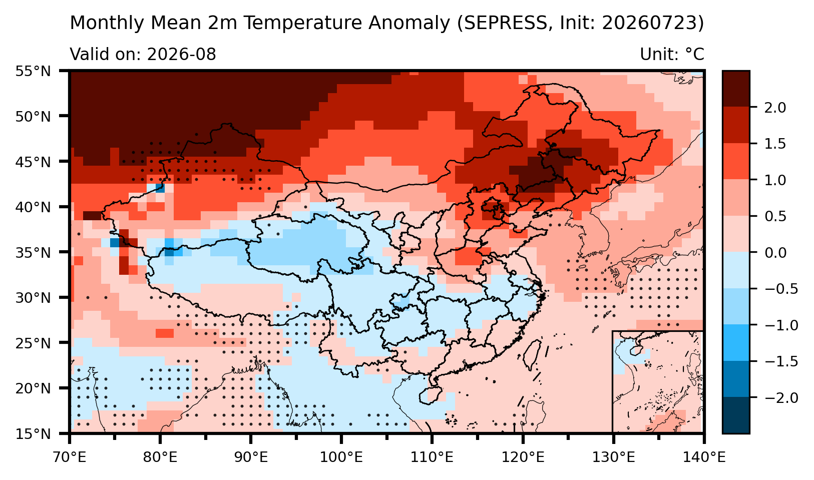
In August 2026, China's surface temperature will be characterized by an overall "warm in the north, cool in the south" distribution pattern. Specifically, temperatures in most of Xinjiang, Inner Mongolia, Shaanxi, Shanxi, Henan, Hebei, Beijing, Tianjin, Shandong, Liaoning, Jilin, and Heilongjiang will be higher than normal, with northern Xinjiang, eastern Inner Mongolia, Hebei, Beijing, Tianjin, Henan, and the three northeastern provinces experiencing the most significant warm anomalies, locally exceeding 1.5–2.0°C. In contrast, temperatures in most parts of northern Tibet, Qinghai, Gansu, Sichuan, Yunnan, Chongqing, Hubei, Hunan, Guizhou, Jiangxi, and Zhejiang will range from near-normal to lower than usual, with localized areas in Qinghai, Tibet, and Chongqing lower by 0.5–1.0°C.
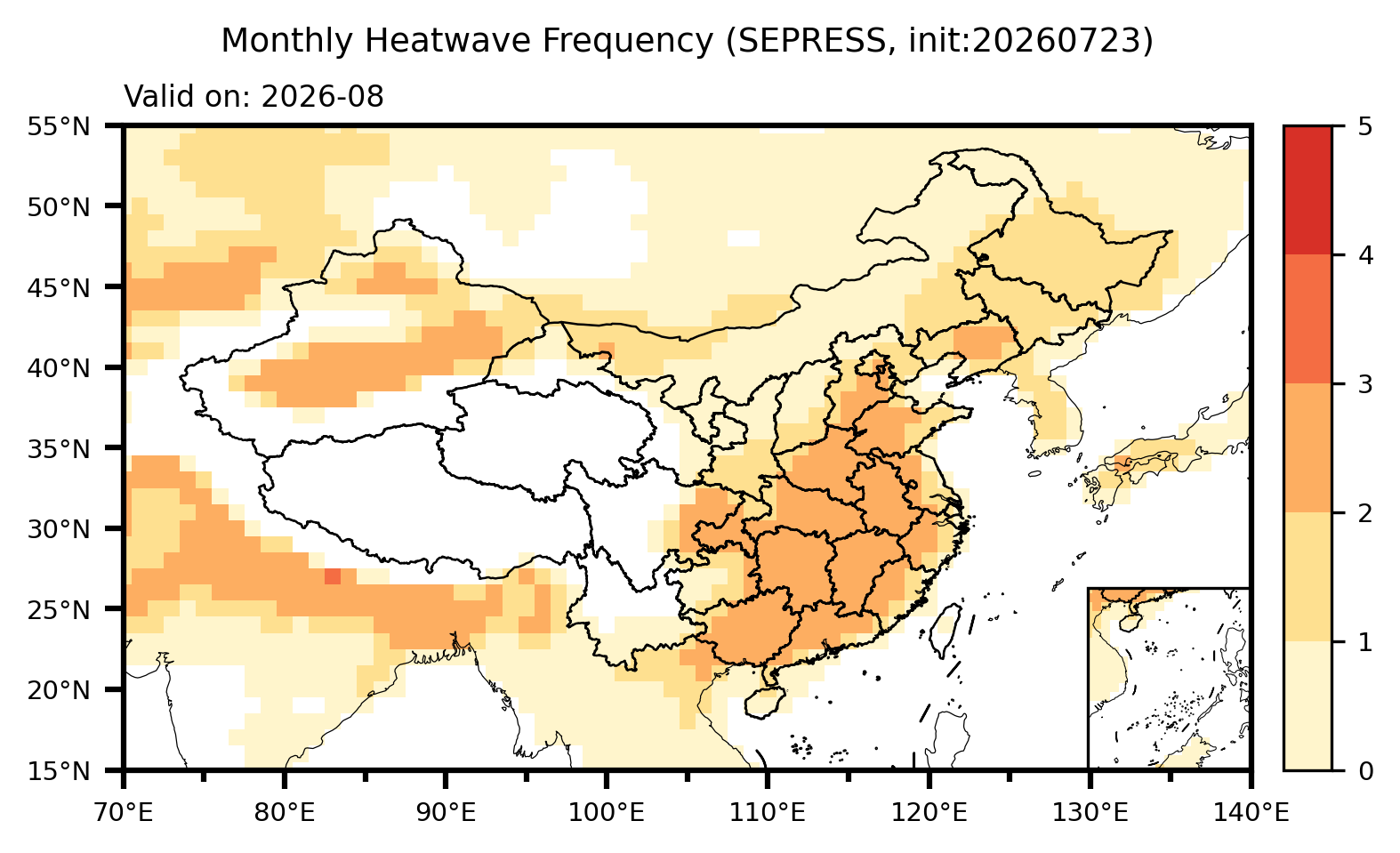
Predictions for persistent heatwave events indicate that North China, Central China, East China, South China, as well as the Tarim Basin and the southern Junggar Basin in Xinjiang, will be high-risk regions for persistent heatwaves, with 2–3 persistent heatwave events expected to occur during August.
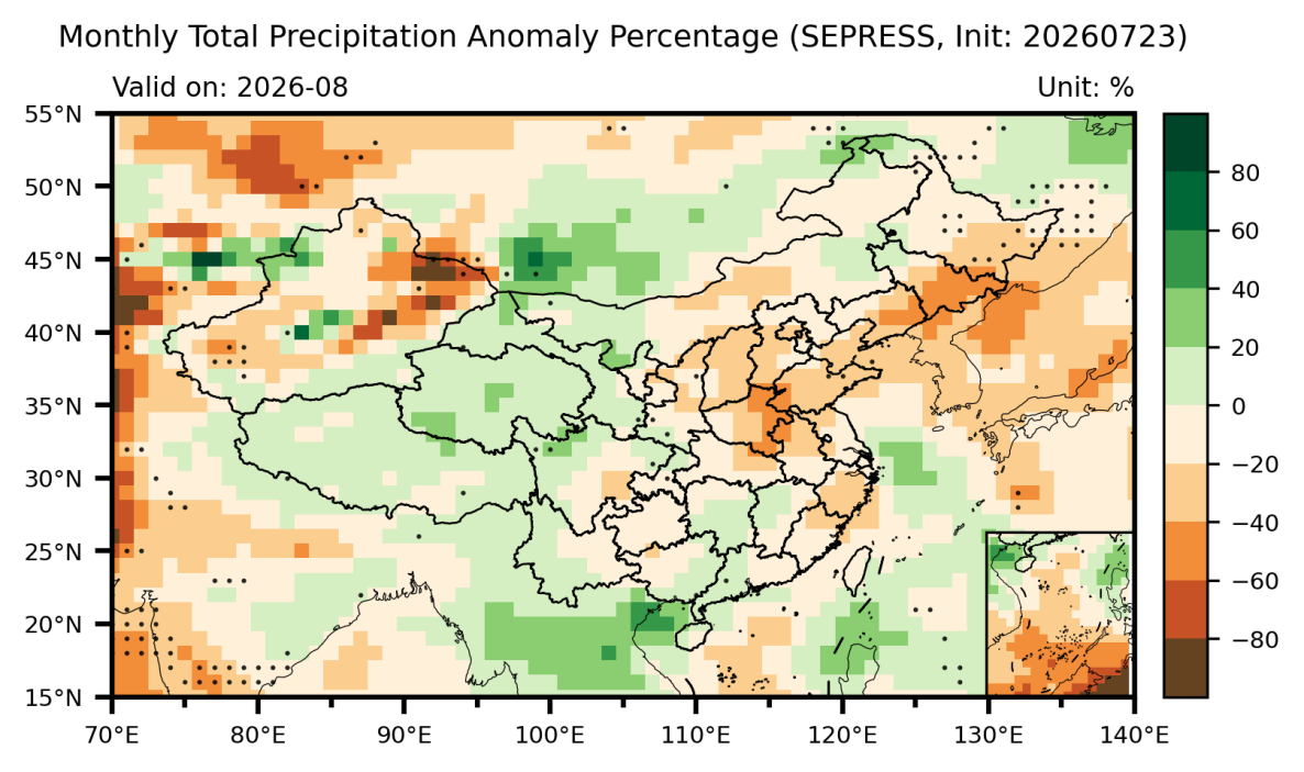
Regarding precipitation, China is expected to exhibit an overall distribution pattern of "above-normal in the west, central-north, and localized South China, and below-normal in the east and northwest". Precipitation in western Inner Mongolia, Gansu, Qinghai, Tibet, and western Sichuan will be above normal, with localized surpluses of 20%–40%. In contrast, precipitation in eastern Inner Mongolia, most of Xinjiang, Liaoning, Jilin, Heilongjiang, Shandong, Henan, Shaanxi, Shanxi, and parts of the southeastern coastal areas will be below normal by 20%–60%, presenting a certain risk of meteorological drought.
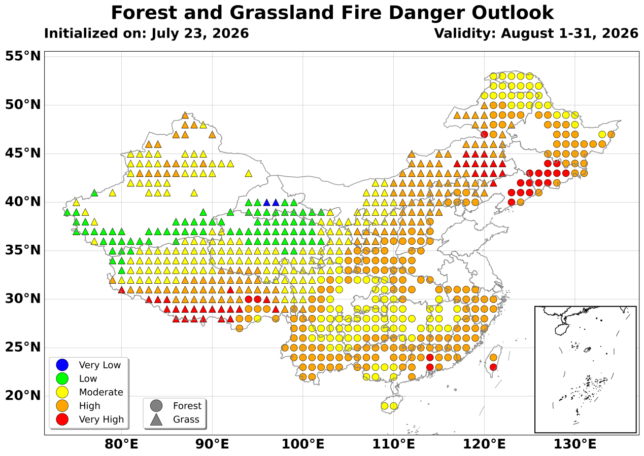
In August 2026, the overall forest and grassland fire danger rating across China is expected to be moderate risk. Specifically, southern Tibet, central Guangdong, eastern Inner Mongolia, and the border area between Liaoning and Jilin provinces face a high risk of forest and grassland fire danger.
Reference:
Pan, Y., Yang, J., Yao, Q., et al. (2024). How well do multi-fire danger rating indices represent China forest fire variations across multi-time scales. Environmental Research Letters, 19, 044002, https://doi.org/10.1088/1748-9326/ad2d3d.
Pan, Y., Yang, J., Lu, M., et al. (2025). Bridging the "Last-mile Gap" in Climate Services Delivery: A Dynamical-AI Hybrid Framework for Next-Month Wildfire Danger Prediction and Emergency Action. Advances in Atmospheric Sciences, https://doi.org/10.1007/s00376-025-5091-4.
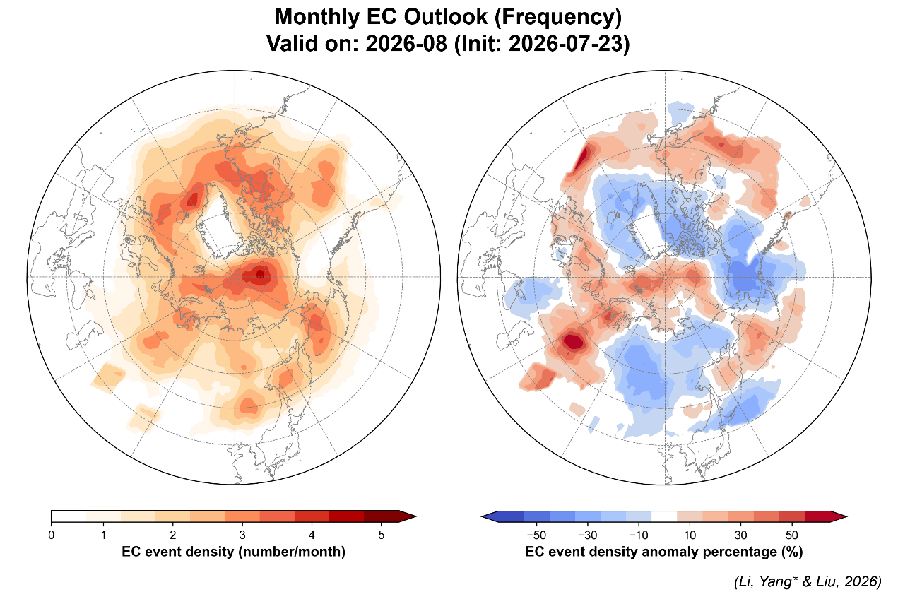
Predictions for Northern Hemisphere extratropical cyclones indicate that cyclone activities in August will be significantly above normal over the central Arctic Ocean, Bering Sea, Arctic Ocean–Eurasian coast, North American continent, and mid-latitude North Atlantic, with Central Siberia also exhibiting a prominent anomaly of active cyclones. Conversely, cyclone activities over Alaska, the Arctic Ocean–North American coast, and the Far East will be suppressed, with frequencies significantly below normal.
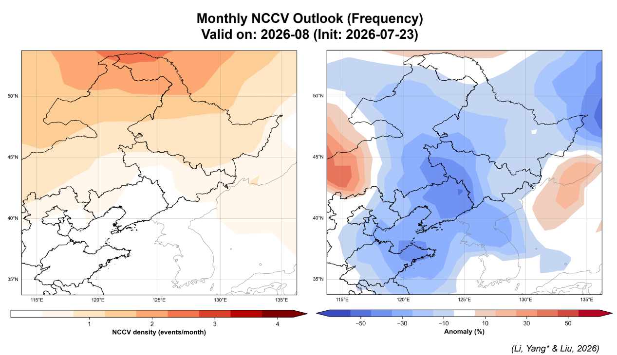
Forecasts for the Northeast Cold Vortex (NECV) indicate that cold vortex activities over China will be weak in August. Most of Northeast China, the Bohai and Yellow Seas, and the Shandong Peninsula are projected to be influenced by cold vortices 20%–40% less frequently than normal. However, contrast exists in localized regions: the frequency of cold vortex influence will be 20%–40% above normal in central Inner Mongolia and north of the Beijing–Tianjin–Hebei region, while the border region between northern Heilongjiang and northern Inner Mongolia will be the most active area for cold vortices this month, with an estimated 2 to 3 influencing occurrences.
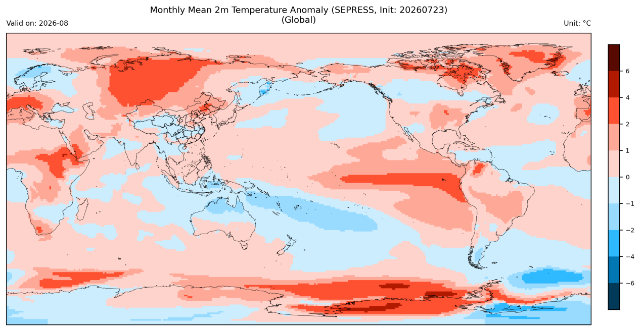
Global near-surface temperatures in August 2026 will be predominantly warmer, with high-latitude regions of Eurasia, northern North America, Greenland, and parts of Antarctica experiencing warm anomalies of 2–4°C. Meanwhile, temperatures in localized parts of southern Asia, central North America, and northern Oceania will range from near-normal to slightly below normal.
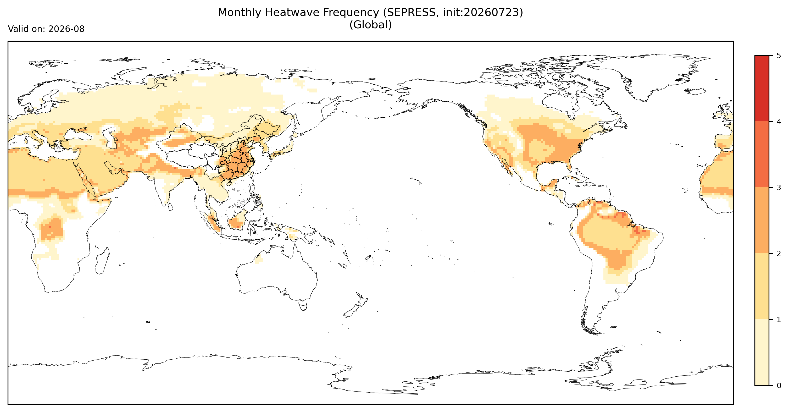
Predictions for persistent heatwave events show that the central-eastern United States, north-central South America, North Africa, and parts of South and Central Asia will be high-risk regions for global persistent heatwaves, with 2–3 persistent heatwave events expected to occur during August.
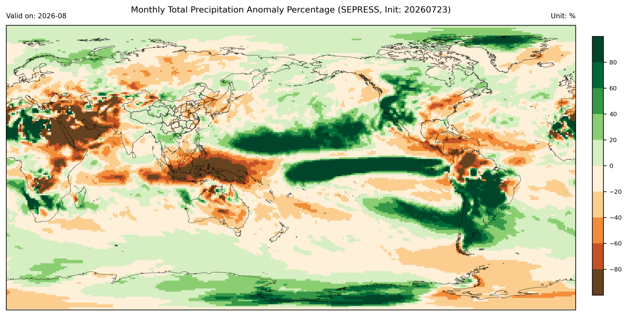
Global precipitation will exhibit significant spatial disparities. Influenced by the El Niño event, precipitation will be significantly above normal by 60%–80% over the equatorial central-eastern Pacific, mid-western North America, south-central South America, and northern Africa. Conversely, precipitation over the Maritime Continent, equatorial western Pacific, South Asia, Western Asia, Oceania, and northern South America will be below normal by 60%–80%.
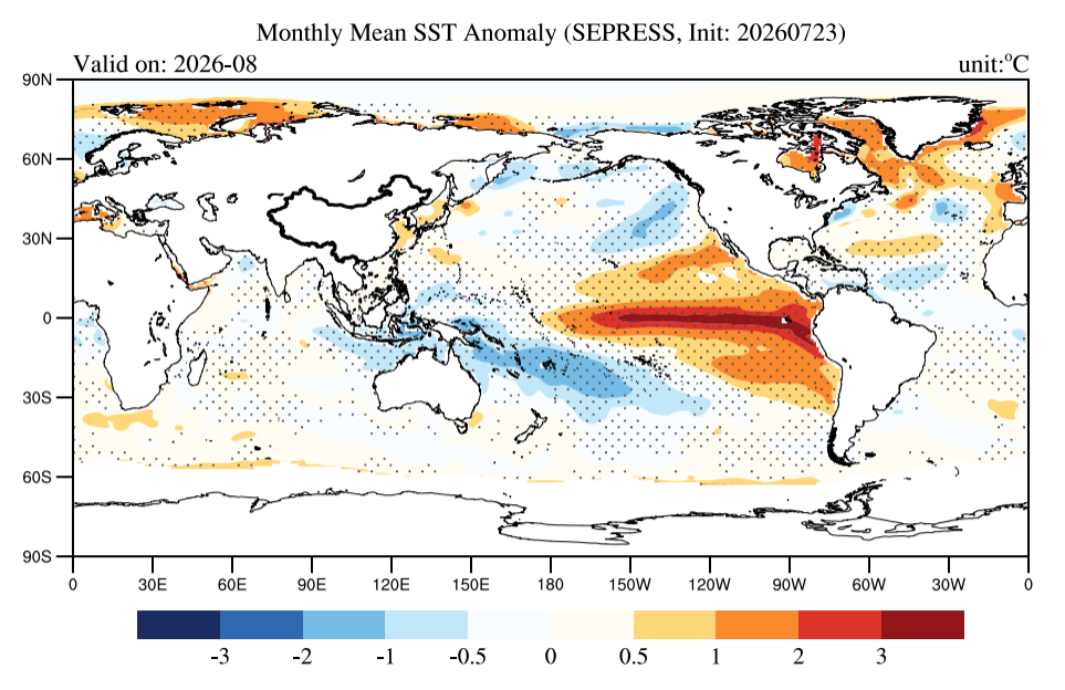
Global Sea Surface Temperature (SST) forecasts indicate that in August 2026, positive SST anomalies in the equatorial central-eastern Pacific will widely exceed 2°C, with a strong El Niño event continuing to develop.
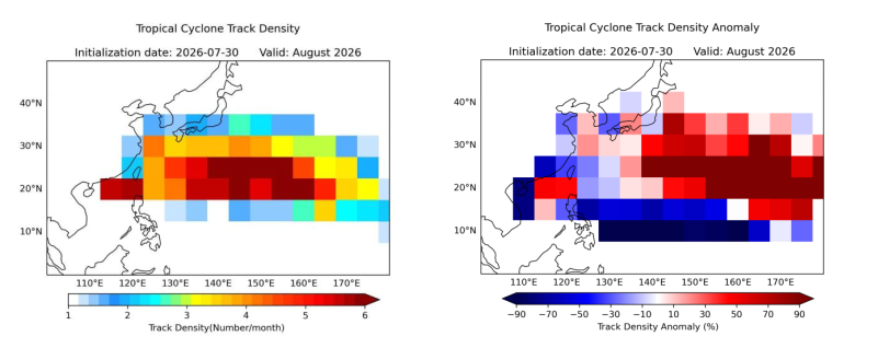
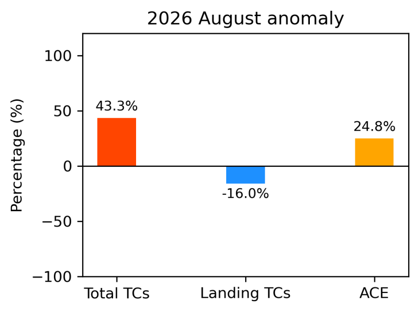
Tropical Cyclone (TC) activity predictions over the western North Pacific show that TC activity in August 2026 is expected to exhibit features of "active genesis, a northeastward-shifted path, and near-normal landfalls". Driven by anomalous SST warming in the tropical Pacific and related large-scale atmospheric circulation, the total number of TCs generated over the western North Pacific in August is predicted to be 43.3% higher than the historical average. Concurrently, the Accumulated Cyclone Energy (ACE), which reflects the overall destructive potential of TCs, is expected to be 24.8% higher than normal, indicating strong cyclonic activity intensity. Analysis of track density anomalies shows that active TC trajectories will be noticeably shifted eastward and northward compared to normal. Under these combined influences, approximately 2.55 TCs are predicted to make landfall in China in August, close to the historical average level.
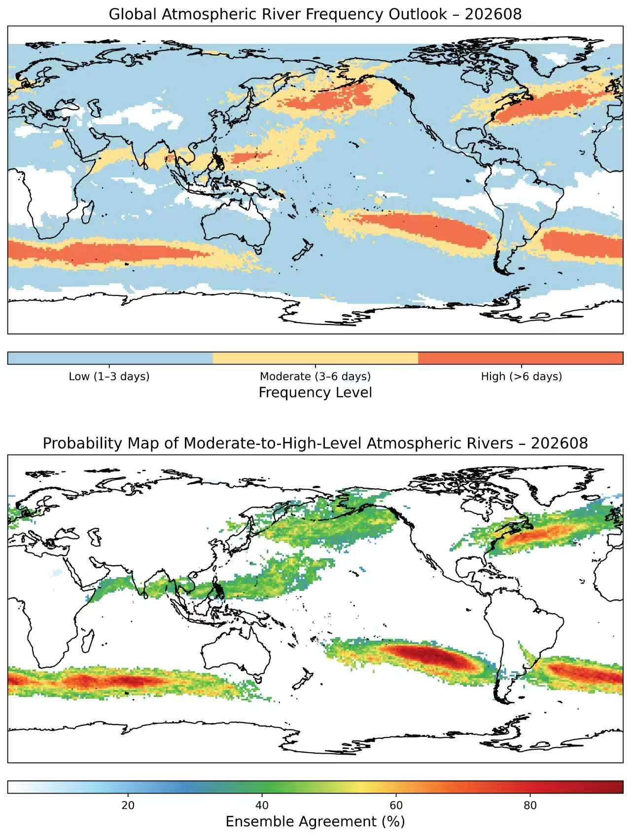
Based on the self-developed atmospheric river identification and tracking algorithm PanLu 2.0, global atmospheric rivers (ARs) for August 2026 were extracted (Figure13). According to the global frequency outlook of atmospheric rivers, moderate-to-high-level atmospheric rivers are highly probable in the region stretching from Japan to Alaska and across the North Atlantic, showing strong consistency among the model ensembles.
Regarding global forest and grassland fire danger, in August 2026, parts of Central Siberia, southern Australia, southeastern North America, northern South America, eastern South America, southwestern South America, southwestern Europe, central-eastern Africa, and Southeast Asia are expected to face a high risk of fire danger.

These forecasts are derived from the objective prediction methods of the SEPRESS team. The associated products represent scientific and technological outcomes intended for technical reference in disaster prevention and mitigation efforts. They should not be used as the sole basis for decision-making. Further tracking and updated forecasts are strongly recommended.
——————————
The above monthly TC outlook is based on the SEPRESS Global Climate Seamless Prediction System. SEPRESS, or Seamless Prediction and Services for Sustainable Natural and Built Environments, is a global initiative led by the Hong Kong University of Science and Technology (HKUST) that translates scientific advancements in weather-to-climate (or, subseasonal-to-seasonal) prediction into practical, tailored solutions to enhance global climate resilience and sustainability. The initiative, endorsed by UNESCO, aims to bridge the gap between science and society by fostering partnerships and delivering actionable outcomes to support the UN’s Sustainable Development Goals. The SEPRESS team comprises hydrometeorologists and modelers from the HKUST, the Institute of Atmospheric Physics (Chinese Academy of Sciences), and Beijing Normal University.
Text and Figures contributed by: QIAN Siyu, Dipendra LAMICHHANE, SONG Yurong, ZHOU Qinyao, LI Shentong